Page 1 of 3 123 LastLast
Results 1 to 10 of 27

Thread: BGR and GPS

  1. #1
    Senior Member SteveS's Avatar
    Join Date
    Oct 2007
    Location
    Nottingham
    Posts
    428

    BGR and GPS

    What are people's thoughts on using GPS on BGRs?

    Obviously taking one is a good safety backup in case of injury, but what about using it for navigation when the clag's down?

    At the weekend I used one for the first time on leg 3, cloud wasn't too bad really until 700m, and though map and compass were turned to first, it did provide a very useful reassuring aid.

    Clearly it's no substitute for proper recce-ing (I've done most of the route now in very poor visbility), but it certainly makes life easier, and the less to worry on the day the better!

    I just can't help but feel it's cheating, by reducing the mountain skill required to solely keeping moving...

    Steve

  2. #2
    Senior Member Tea's Avatar
    Join Date
    Mar 2008
    Location
    staying with my Uncle Dave
    Posts
    139

    Re: BGR and GPS

    Quote Originally Posted by SteveS View Post
    I just can't help but feel it's cheating
    Well if that's how you feel about using it on your BGR, then anything anyone says here is unlikely to change your mind about that.

    It's your BGR that matters. There are a whole range of questions like "did Bob use a compass?" which are about as much real use as "how long did Bob hardboil his famous eggs for?".

    Unless anyone is going to be troubling Billy for his record, then we all set our own rules (like in so much of life), don't we?

  3. #3
    Senior Member Dog Breath's Avatar
    Join Date
    Apr 2007
    Location
    Wirral Alps
    Posts
    139

    Re: BGR and GPS

    On the day, won't your helpers be navigating, thereby taking the responsibility away from you? Is that cheating ?

  4. #4
    New Member
    Join Date
    Mar 2008
    Posts
    2

    Re: BGR and GPS

    What is the difference between using outside help in the form of numerous navigators, motivators and pacers as well as helpers waiting at the road crossings with hot food, fluid and changes of clothes or outside help in the form of a GPS. My initial thoughts would be that a solo attempt with a GPS as your navigator would more than stand up to a support crew assisted attempt.

  5. #5
    alwaysinjured
    Guest

    Re: BGR and GPS

    Quote Originally Posted by SteveS View Post
    What are people's thoughts on using GPS on BGRs?

    Obviously taking one is a good safety backup in case of injury, but what about using it for navigation when the clag's down?

    At the weekend I used one for the first time on leg 3, cloud wasn't too bad really until 700m, and though map and compass were turned to first, it did provide a very useful reassuring aid.

    Clearly it's no substitute for proper recce-ing (I've done most of the route now in very poor visbility), but it certainly makes life easier, and the less to worry on the day the better!

    I just can't help but feel it's cheating, by reducing the mountain skill required to solely keeping moving...

    Steve

    Maybe Im just a purist,

    but in my view the answer should be no.

    Bob Grahams team, didnt have a GPS!!

    Anyway it adds to the fun.....

    Navigated a couple of legs last year where you couldnt see even 10 yards in front. Starts to get interesting!...

  6. #6
    Headmaster Grouse's Avatar
    Join Date
    Jan 2007
    Posts
    3,377

    Re: BGR and GPS

    And they didn't have gore tex, modern fellshoes wicking fabrics etc. etc. so anyone who doesn't do it in a pyjama top with hardbolied eggs and plimsolls is cheating. And did they have contact lenses in 1932 or whenever it was?

  7. #7
    New Member
    Join Date
    Mar 2008
    Posts
    2

    Re: BGR and GPS

    Also did Bob Grahams team drive from all over the country in modern motor cars with perfectly smooth sealed roads and direction signs on every turn to get them to The Lakes. Did they arrange recce runs via the internet and use forums to get training and route information. Did they use the modern sports science knowledge base that has created isotonic drinks, energy bars and gels? I am just curious about this selective use of technology and what pure really is?

  8. #8
    Master
    Join Date
    Jan 2007
    Location
    Cumbria
    Posts
    2,088

    Re: BGR and GPS

    PURE :- Free of any extaneous elements of any kind.

    So based on that there has only ever been one pure round and that was BOB GRAHAMS.

    I can`t really see the need for a GPS after all it seems that groups just follow one another round during busy periods.

    Have Fun
    The older I get the Faster I was

  9. #9

    Re: BGR and GPS

    THere are only three rules as far as i can see for the 24 hour club:

    Start and finish at the moot hall within 24 hours

    Visit the named 42 summits in between

    Do so under your own power


    That's it, and it's perfectly hard enough with or without GPS, skilled and knowledgable navigators or hard boiled eggs.

    If you want to add your own rules for your round to do it your way, great! Just don't judge anyone else's attempt based on your rules. It's not about anyone else anyway, it's about yourself so do it your way, whatever that is.

    My round was done in really bad weather for the most part and i had a GPS strapped to my wrist. I can tell you honestly that i never used it to navigate as I;d recced and so had my helpers. I almost forgot i was wearing it - in fact having it didn;t stop us wondering off Pillar the wrong way for 5 mins!

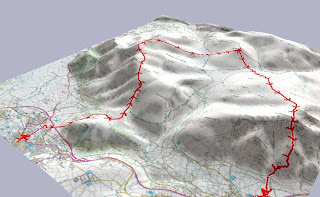
    What it was good for was plotting the line i took and timestamping each summit. That tracklog is such a terrific momento from the day and so i'm so glad I took it.

    Last edited by Mark Smith; 20-03-2008 at 09:16 AM. Reason: to add funky tracklog/map thingy

  10. #10
    Master
    Join Date
    Jan 2007
    Location
    Cumbria
    Posts
    2,088

    Re: BGR and GPS

    Quote Originally Posted by Swiss Toni View Post
    THere are only three rules as far as i can see for the 24 hour club:


    What it was good for was plotting the line i took and timestamping each summit. That tracklog is such a terrific momento from the day and so i'm glad it took it.


    Exactly what i use mine for
    The older I get the Faster I was

Posting Permissions

  • You may not post new threads
  • You may not post replies
  • You may not post attachments
  • You may not edit your posts
  •