Sounds entirely sensible. After all they're both respiratory diseases.Originally Posted by Witton Park


Sounds entirely sensible. After all they're both respiratory diseases.
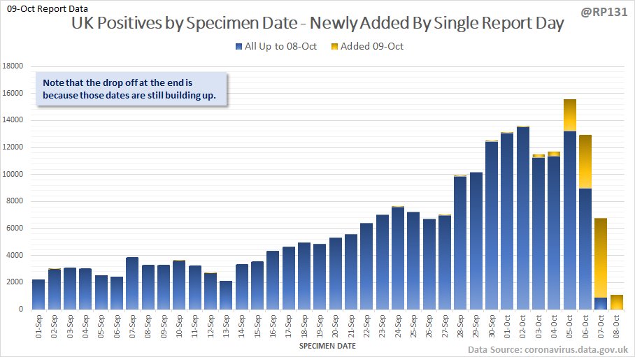
Prof Carl Heneghan has been pointing this out for weeks.
It is one thing for me to be appalled, disheartened and in despair at the incompetence of our politicans to deal calmly, logically and effectively, with the Covid crisis - but that is as nothing in comparison to what, say, world-renowned epidemiologists must be feeling.
World leading epidemiologists don't have to consider the economy.
Visibility good except in Hill Fog

Looking at this BBC map https://www.bbc.co.uk/news/uk-54373904 (bottom of the page) of the UK, it really doesn't seem credible that all of the 'problem' areas are noth of a line running from tht Wash to the river Severn. I smell a gigantic rat!
No 'hot spots' in the SE or the SW, with all of their dense populations and numerous universities. Do me a favor! There's some statistical manipulations going on here for sure.
Am Yisrael Chai
True and it now looks like The Guardian as trying to do a hatchet job by smearing those that contributed to the Great Barrington Declaration. https://unherd.com/thepost/is-the-gu...on-scientists/
Reddit also reportedly taking down postings of the Declaration.
Am Yisrael Chai
Hmmm like the the governments of China, Taiwan, South Korea, Japan, Australia and New Zealand then 🤔
Haha what about the moon landings mossdog?
Simon Yates out the Giro with the lurgy
don't blame the meedja, it's been signed by experts such as Dr Johnny Bananas, Professor Cominic Dummings and someone who went to the University of Your Mum. Someone else's name is apparently the first verse of the Macarena. Sky News (not the Gruniad) apparently discovered 18 self-declared homeopaths in the list of expert names and more than 100 therapists whose expertise included massage, hypnotherapy and Mongolian khoomii singing.